Wednesday, September 30, 2009

September 30, 2009

This morning when we awakened, the wind had died, the lake was smooth, and the sun was shining. Quite a change from the last couple of days!


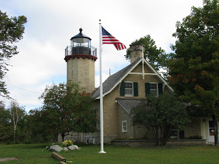
When we left Mackinaw City, we headed west to McGulpin Point Lighthouse. The lighthouse lies on the Mackinaw Straight about three miles from Mackinaw City. The lighthouse was built in 1868 and was decommissioned in 1906. It was sold to a private owner in 1913 and remained in private hands for over ninety years. During that time the lantern room was removed and a roof was built over the opening. The property was put up for sale and stayed on the market for several years before it was purchased for $750,000 in the summer of 2008 by Emmet County. Since then, a new lantern room has been installed along with other repairs to the building. A trail has been built to the beach and several trees have been removed between the lighthouse and the beach. The residence part of the house is being returned to its original look and will house a museum dedicated to the lighthouse and the McGulpin family land claim.


Our next stop was the Legs Inn (second photo) in Cross Village, MI for lunch. Legs Inn was built by Polish immigrant Stanley Smolak who settled in Cross Village in 1921. The restaurant offers authentic Polish cuisine, and American dishes. We both had the Pierogi (Polish style dumplings steamed on the grill and filled with your choice of lightly seasoned ground sirloin, potato and Farmer’s cheese, or sauerkraut with mushrooms), and it was delicious.


We finished our meal with their “Old Fashioned Polish Berry Szarlotka” (third photo), …very big and very good!


After leaving the restaurant, we ventured into the Cross Village Rug Works which is opposite Legs. This enterprise was established in 2007 and has 30 Artisans. Wool is sheared from local sheep, cleaned and dyed. Rugs are then woven from the yarn (fourth photo). They can produce commissioned rugs and punch needle tapestry.


Our sign of the day was spotted near Marquette, MI. Too many rocks!


Tonight we are in Traverse City, MI. Tomorrow we will be headed to the Cherry Republic and The Sleeping Bear Sand Dunes. We promise to eat a few cherries for you!

T&C

Tuesday, September 29, 2009

September 29, 2009

Lake Michigan was quiet in Manistique this morning. The wind had changed direction and the waves were down to about two feet. On the other side of the UP, Lake Superior was still producing waves of twelve to fifteen feet.


Our destination today was Mackinaw City, MI. To get there we had to cross the Mackinac Bridge and we were not looking forward to that. A few miles before we reached the bridge, we stopped at an overlook and took a photo of Lake Michigan (first photo). This overlook is about one hundred feet above the lake and offers a good vantage point for viewing the lake.


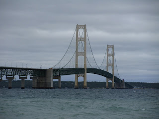
As we approached the Mackinac Bridge (second photo), the posted speed for trucks was down to 20 mph, and for cars it was 40 mph. This was necessary due to the high winds and the height of the bridge over the lake (over 200 feet). Trucks also had to travel using their emergency flashers.


Our attraction today was the Mackinaw Lighthouse (third photo). The lighthouse was put into service in 1892. When the bridge was completed in 1957, the lighthouse was decommissioned because the bridge had its own navigation lights and fog horns.


We tried to get a good photo of the bridge after dark (fourth photo) but the wind is still blowing about 20 mph. The camera moved a little during the timed photo.


Our sign of the day was spotted in Gulliver, MI.


Tomorrow we will be heading to Traverse City, MI. This means we will soon be visiting The Cherry Republic…more things to taste and smell!
T&C

Monday, September 28, 2009

September 28, 2009

The sky was dark this morning so we decided to change our plans for the day. We headed east to the Seul Choix Point Lighthouse. Seul Choix is pronounced Sis-Shwa and translates to “Only Choice”. The harbor at Seul Choix was the only choice for the early travelers seeking refuge from the storms on Lake Michigan.


The Seul Choix Lighthouse was built in 1895 (photo one). The keeper’s house (two story part) has seven rooms and one bath.


The one story part on the left side was the assistant keeper’s dwelling and only contained four rooms. The trim around the interior doors is solid copper (photo two). This is the only part of the house that contains copper trim. It is also the only lighthouse known to have this type of trim. Even after research, it is still a mystery as to why the trim was fashioned in this manner.


The tower is seventy-nine feet nine inches tall. You have to climb ninety-six steps to reach the top. The third photo is of Cheryl coming through the last hatch before reaching the top. Seul Choix is the only lighthouse that we have encountered that has had more than one hatch. This one has two, with one being on the level just below the top level.


In order to be able to withstand the storms of the lakes, the lighthouses are built with very thick walls. Some reach a thickness of four feet or more. The fourth photo shows a window near the top of the lighthouse. At this point, the wall thickness measures between 32 and 36 inches.


This was a very impressive lighthouse due to the painstaking restoration, and the interior which is in “like new” condition. The historical society’s next project is to paint the tower and house. Currently there are no state grants available and the group must work off donations. The project is also aided by lots of community involvement.


Remember the lighthouse with the wave breaking over it? This is what it looks like when the lake is calm (photo five). The Calumet area of the Keweenaw Peninsula that we left on Sunday morning is getting 15 foot waves on Lake Superior this afternoon. Winds are expected to reach 50-55 mph. There were pictures on TV this afternoon of surfers on the beaches! Wish we had been there to see them.


Our sign of the day is another statue. We caught this “couple” walking along US 2 just east of Manistique.


Tomorrow we will be headed towards the Mackinaw Bridge (all five miles of it). Let’s hope the wind has died! Cheryl and I do not have any water wings!!


T&C

Sunday, September 27, 2009

September 27, 2009

We loaded up this morning and headed south, leaving the Keweenaw Peninsula behind. For some reason we had more to bring back across the lift bridge than upon our arrival. We also brought a lot of memories back…beautiful scenery, friendly people and the taste of good food. We backtracked our route for 90 miles (back to Marquette, MI) and headed south on US41. Crossing the UP from Marquette to Manistique is much like driving in South Carolina towards Myrtle Beach. The roads are flat and straight, and compared to the north shores with its beautiful scenery, very boring.


I did get a couple of good barn photos (photo one) for a friend, but the rest of the trip didn’t turn up much to photograph until we reached Lake Michigan.


Our first view of Lake Michigan was west of Manistique. The wind was blowing about 15-20 mph and there were a few waves running 2-3 feet (photo two). Check out the geese, and a few mallards.


By the time we got to Manistique, the wind had increased to 25-30 mph. Waves coming to shore had increased to 4-6 feet (photo three). There were a lot of people out taking pictures of the waves.


The fourth photo is of the Manistique East Breakwater Lighthouse. Waves were smashing into, and crashing over the breakwater wall. The lighthouse stands about 50 feet tall from the water to the top.


Monday’s weather calls for higher winds and some rain; it may be interesting in the morning!


Our sign of the day turned out to be a statue of the day.We have been hoping to spot a moose for two years and today we finally did…he certainly is a Big Boy!


Tomorrow we will be touring the Seul Choix Point Lighthouse and visiting a Ghost Town. If you would like to adopt a ghost, please let us know and we will try to make the necessary arrangements for you. We could bring him/her back with us!
T&C
Saturday, September 26, 2009

September 26, 2009

Get up late, do nothing (almost) and smell the roses. After 13 days on the road we did just that, and it was time for a break. We took a few pictures of the Calumet, MI business district, stopped at an antique shop, a yard sale, and last but not least, Walmart.

Calumet was built in the late 1890’s, has several brick streets and operates at a very slow pace.


The first photo is of the fire house. It now serves as a museum.


The second photo is of the old hotel. It now houses the Michigan House Café & Red Jacket Brewing Co.


The third photo is of the opera house which is still is a center of entertainment for the area. They were having a benefit today that featured different bands from 2 pm to 10 pm.


The fourth photo is of the Portage Canal Lift Bridge. It connects Houghton, MI with Hancock, MI and the rest of the Keweenaw Peninsula. It is the heaviest lift bridge in the world.


Our sign of the day is a note that was on the door of an antique shop in Calumet. We tried three times, twice during the “regular” open hours, to get in. We didn’t have any luck.


Tomorrow we leave behind the Keweenaw Peninsula and Lake Superior. We will head south to Manistique, MI and Lake Michigan.


T&C

Friday, September 25, 2009

September 25, 2009

Today we traveled up the north shore of the Keweenaw Peninsula. This side of the peninsula is very different from the south side. The south side is fairly flat with sandy beaches and a few rocky areas, while the north side has a lot of large rock formations and very rocky beaches.


The first photo was made near Eagle Harbor. Note the very rocky coast. You can also see some rocks jutting from the water in the center left of the photo. These rocks are about 200 yards off shore.


Our second photo is of the Eagle Harbor Lighthouse, built in 1871. It is maintained by the Coast Guard. We were able to see most of the lighthouse, but not able to climb it because it is operational.


We stopped several times along the coast to take a lot of photos and add a few rocks to the collection. The vehicle groans every time we come back with additional stones! We also met a lot of travelers today that had time to talk about the Great Lakes and share some wonderful stories about the area.


Lunch today was in Copper Harbor at The Mariner North. Copper Harbor is much like a small North Carolina coastal town with its gift shops and restaurants. In a way, it seems to be out of place with everything else on the eastern peninsula.


While there, we took a few photos of the Copper Harbor Lighthouse (photo three) which has fallen victim to the development of Copper Harbor. Due to the sale and development of the land around it, the lighthouse is now land locked and can only be visited by boat.


From Copper Harbor we headed west on US41 on our way to the Delaware Copper Mine. The mine was opened in 1847 and operated until 1887. If you remember back a few days, we climbed the tallest lighthouse on the Great Lakes. Today we descended 110 feet to the first level of the mine. This was another first for both of us. The mine is very dimly lit in order to make it as realistic as possible. I did take a flashlight with us and we did need it at times to navigate the tunnels. Did I tell you that this is a self guided tour and we were the only humans down there?
The tour begins by descending 100 steps that take you to the first level.

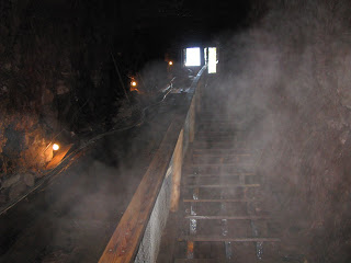
The fourth photo is looking up those steps. Fog is created by the moisture in the mine and its 45 degree temperature meeting the outside air coming down the shaft. The shaft is a 35 degree angle. You walk over a quarter mile through the tunnels with the roof ranging from 6 feet to about 30 feet.


The rock is a red color (photo five) and the copper in it looks green. Over 8,000,000 pounds of copper came out of this mine.


Photo six shows one of the tunnels we walked. The white on the walls are seams that contain the copper.


Photo seven is of us on level one. I almost forgot this item…the mine is 1400 feet deep and has ten levels. All but the first lever are flooded. When the mine was in operation, there were pumps that continuously pumped out the water.


Remember earlier that I said we were the only humans in the mine. Photo eight is of our “partners”. This is 2 of about 50 that were seen. The owners said there will be hundreds before winter comes!


And our sign of the day has us wondering: what are the bears registering for?


Tomorrow is a day of rest. We are not sure what we will be doing. Tune in…we may have a surprise.

T&C
Thursday, September 24, 2009

September 24, 2009

We are staying at an Americinn Motel in Calumet, MI. Their breakfast bar is a little above the average motel. One thing that contributes to this is their waffle machine. It takes 2 ½ minutes from start to finish, and they are really tasty!


We had a light day planned for today so we took our time getting ready to leave this morning. It was just a 17 mile drive to our first stop, The Gay Bar in Gay, MI. We were a little early getting there so we drove around town and took a few pictures. Gay was founded by Joseph E. Gay and was the home of the Mohawk Mining Company stamp mill. The stamp mill separated the copper from rock which was removed from the copper mines. After the mines closed, the town’s population dropped from over 1,500 residents to about 50 today. When the mill closed, they sold the houses for $1.00 a room; thus a five room house was $5.00. The only thing left from the stamp mill is the smokestack.


The Gay Bar (first photo) is the only business left. They are famous for their ¼ pound hot dogs, all 25 different kinds. I did get my Chicago dog and Cheryl had a chili dog. We also had a root beer float. Root beer is a very popular drink in this portion of the state.


After we left Gay, our drive took us up the south side of the peninsula. This is the first area of Lake Superior where we have encountered a shale type rock base along the beach. The rock is red in color and very soft. If you enlarge the second photo, you can see the layered shale in the bank. This photo was taken looking east.


About 25 miles east of Gay is a little village called Bete Grise, MI. Bete Grise is much like Gay in that when the mines closed, it too lost most of its population. Bete Grise Beach is famous for its singing sand. If you rotate your hand or bare foot in the sand, the sand resonates, producing a singing sound. The sand is very fine. I have seen this on some of the ocean beaches.


The third photo is of the postman delivering mail to the Bete Grise area. Everyone gets their mail at the same location. Notice the blue mailbox on the left for outgoing mail.


The highest point on the Keweenaw Peninsula is Brockway Mountain. The top of the mountain is bald and offers a fantastic 360 degree view of the lake and mountains. The observation area is 726 feet above the lake and 1328 feet above sea level. The fourth photo is of a flock of geese that took off from the beach and ascended to our level as they headed south. Enlarge this photo and you can see the outstretched feet on several of the geese. The background is Lake Superior looking north from the mountain top.


Our sign of the day, and last photo, is a “yardstick” showing the snowfall for last year (2008/’09). Note the red pointer at 284 inches. The all time record (note top) was in the winter of 1978/’79 at 390.4 inches. The 48 year average is 240.9 inches. The area is not for those who suffer from cabin fever, or are afraid to navigate the white stuff!
Tomorrow we will be checking out the northern side of the peninsula.
T&C

Wednesday, September 23, 2009

September 23, 2009

Today we traveled from Munising, MI to Calumet, MI, located on the Keweenaw Peninsula. Most of our drive paralleled Lake Superior and offered up numerous opportunities to photograph the scenery.


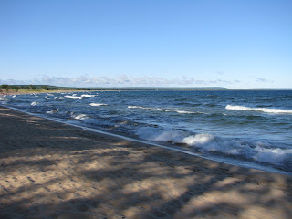
Shortly after leaving Munising, we stopped at a roadside park along the edge of Lake Superior. Due to a wind blowing from the northwest, waves about 2-3 feet were rolling in and gave the lake a look similar to an ocean beach (Photo one). The sand in this area is very fine.


The lake’s pounding waves continually wear away the rocks. With this comes many different shapes and figures, each offered up to your imagination. In 1962 the lake carved out a face in a rock at this roadside park. It lasted until about 1998 before it was destroyed by the waves. Photo two was taken just a few feet from the face location. What do you think this rock looks like?


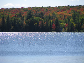
We are starting to see some fall color (photo three). This photo was taken at Lake Ruth, which is part of a group of three inland lakes. There are over 11,000 lakes in Michigan.


Photo four is of Houghton, MI, home of Michigan Technological University. Houghton is the gateway to the Keweenaw Peninsula.


And our sign of the day stands at the entrance to Christmas, MI. Most of the businesses contain Christmas in their name; Christmas Garage, Christmas Motel, etc. I think you get the picture.
Dinner tonight was at The Irish Times Pub in Laurium, MI. It was recommended by the motel manager and proved to be great. The Guinness Braised Beef and the Whiskey Chicken were both mouth-watering. We will probably pay the Pub another visit before we leave town.


Tomorrow we will be heading to Gay, MI and the Gay Bar, the home of 25+ different hotdogs. I plan on having a Chicago dog. We will let you know tomorrow how good they are. If you have been following this blog from the beginning, you could get the idea that we are “eating our way through Michigan”.

T&C

Tuesday, September 22, 2009

September 22, 2009

We don’t have much to write about today. We slept in and took the morning at a very slow pace. We did venture down the road about a mile to the very small (don’t blink) town of Christmas, MI. There is not much there except one shop totally devoted to Christmas, and a casino. It looks like the town had a lot to offer at one time but that is definitely a time in the past.

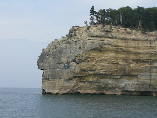
After lunch at Sydney’s, an Australian theme restaurant, we headed to our one adventure for the day: a cruise to the Pictured Rocks National Lakeshore. Pictured Rocks is a national park with cliffs that stretch 13 miles along Lake Superior. The cliffs were formed by the storms on the lake and some are over 200 feet high. Today is devoted to the rocks and their beauty. We took over 100 photos and wish we could share each one.


After our cruise, we returned to Main Street Pizza for dinner. This is a great little locally owned Italian restaurant that we found last year…yum-yum! Too bad there isn’t a Main Street Pizza at home!!
Tomorrow we will again head west. Our destination is Calumet, MI on the Keweenaw Peninsula, the land of the copper mines. Join us.
T&C